Bend, Oregon is beloved for its high-desert climate, pine forests, and rugged volcanic landscapes. One of its most alluring features is the abundance of waterfalls within a short drive. These waterfalls near Bend aren’t just pretty photo-ops; they also offer trail networks, picnic spots, fishing holes, and in some cases, winter recreation. Below is a comprehensive guide to five of the best waterfalls near Bend, including directions, hike details, and insider tips to make your visit memorable.
Read Also:
Best Road Trips in Oregon – Romantic Getaways in Oregon
5 Must-See Waterfalls Near Bend, Oregon
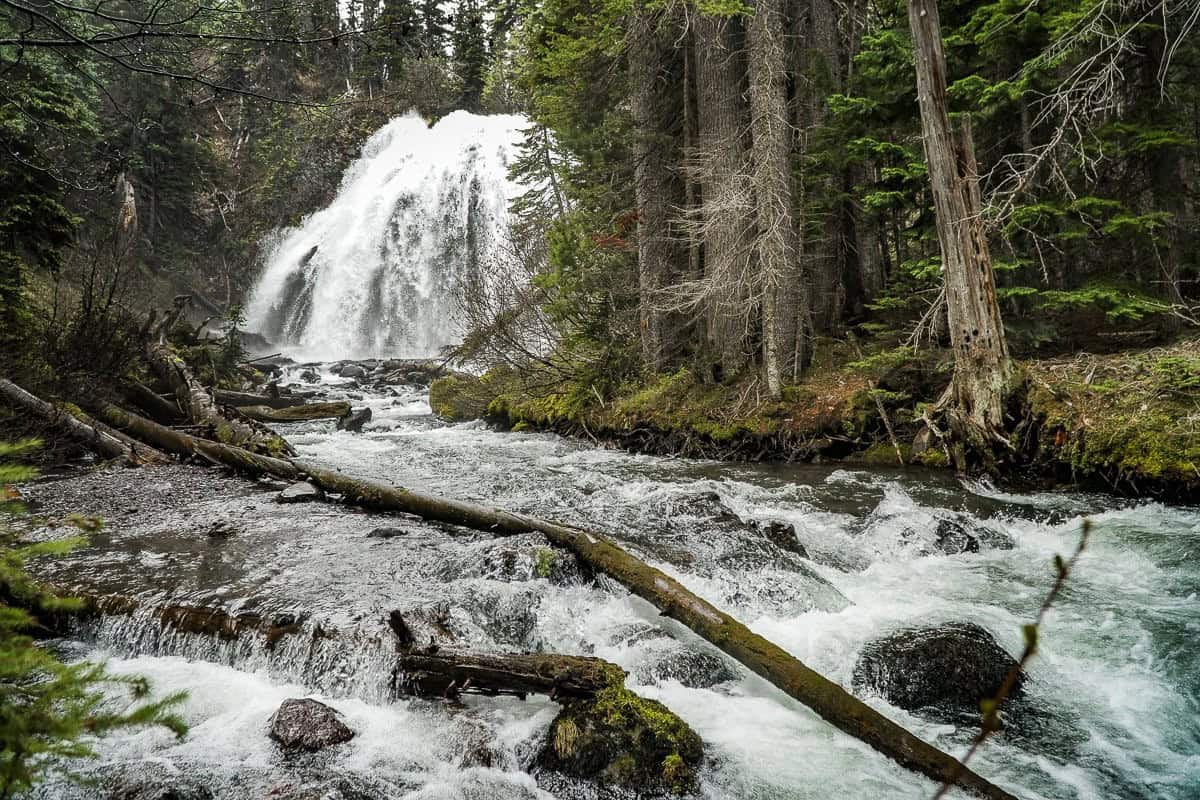
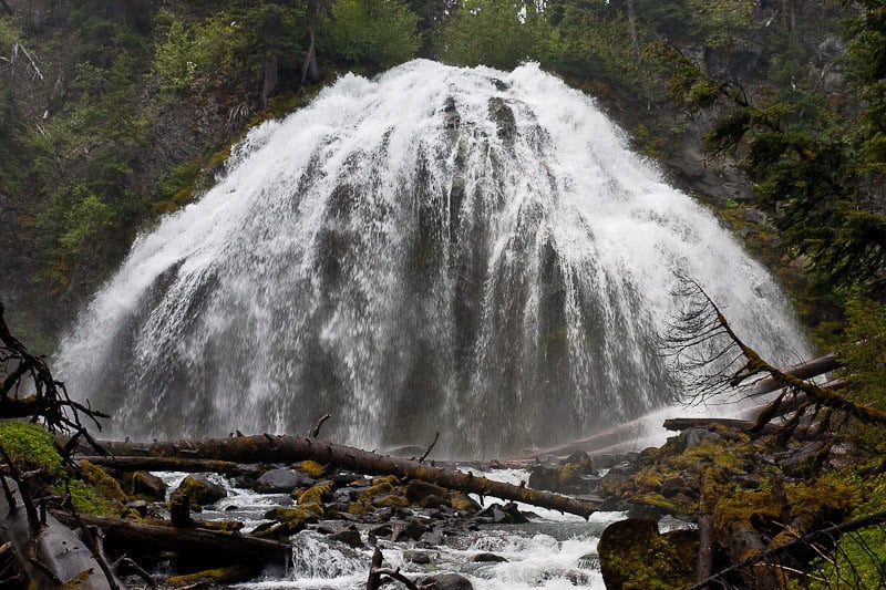
1. Tumalo Falls
Location & Getting There:
Tumalo Falls is situated about 13 miles west of Bend in the Deschutes National Forest. From downtown Bend, take Galveston Ave. to Skyliners Road (Road 4601) and follow it for roughly 10 miles until you reach the Tumalo Falls trailhead parking area. A high-clearance vehicle can be helpful in winter or early spring, as the final mile of the access road can be bumpy or snowy.
Waterfall Details & Appearance:
Standing about 97 feet tall, Tumalo Falls plunges over a basalt cliff into a narrow canyon lined by evergreens. In spring, snowmelt swells the water volume, creating a dramatic roar and mist. Summer reveals a more moderate flow but remains picturesque.
Hike Details:
– Difficulty: Easy to Moderate.
– Distance: A quarter-mile round trip to the main viewing platform, or continue on the North Fork Trail for a series of smaller waterfalls (2–4 miles round trip, depending on how far you go).
– Elevation Gain: About 500 feet if you continue upstream.
– Trail Notes: The initial viewpoint is very close to the parking lot, making it suitable for families or anyone with limited hiking ability. Continuing on the trail adds more creek crossings and steeper sections, so wear sturdy footwear.
Best Seasons & Tips:
– Spring and early summer offer the most dramatic flow, but the road can be muddy or partially snow-covered.
– Arrive early in peak season (June–August) to secure parking, especially on weekends.
– Winter hikes (via snowshoe) provide a quieter experience but require careful navigation if the gate is closed on the main access road.
Tumalo Falls Photo Tips
- Aim for Early Morning Light: Soft, diffused light reduces harsh shadows on the waterfall and highlights the mist rising from the spray.
- Vary Your Angles: The main overlook provides a classic shot, but hiking upstream or downstream offers unique vantage points—try a wide-angle lens for encompassing the surrounding canyon.
- Use a Polarizing Filter: This cuts glare off wet rocks and enhances the greenery around the falls, making colors pop.
- Try a Long Exposure: A shutter speed of 1/4 second or longer creates a silky water effect; remember to bring a tripod to keep the frame sharp.
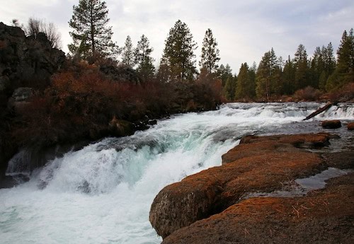
2. Benham Falls
Location & Getting There:
Benham Falls is located about 13 miles south of Bend, on the Deschutes River. From Bend, head south on Highway 97 and take the Exit for Lava Butte/Lava Lands Visitor Center. Follow signs for the Deschutes River Trail and Benham Falls trailhead. Alternatively, you can access it via the Sunriver area.
Waterfall Details & Appearance:
Often described as more of a crashing cascade than a vertical drop, Benham Falls represents the largest rapids on the upper Deschutes River. As the river funnels through a rocky, lava-filled channel, powerful whitewater sections produce a thunderous sound and dramatic spray.
Hike Details:
– Difficulty: Easy.
– Distance: About 1.5 miles round trip from the main trailhead to the viewpoint, depending on your chosen route.
– Elevation Gain: Minimal, under 100 feet.
– Trail Notes: The path runs alongside scenic lava outcrops and stands of ponderosa pine. It’s often used by hikers, trail runners, and mountain bikers. The wide, well-maintained trail is generally family-friendly.
Best Seasons & Tips:
– Year-round accessibility, although icy patches can appear in winter.
– Bring a camera to capture the contrast between blue rapids and dark lava rock.
– Continue along the Deschutes River Trail to explore Benham’s neighboring rapids—Dillon Falls and Lava Island Falls—for a longer day hike.
Benham Falls Photography Tips
- Highlight the Rapids: Because Benham is more of a churning cascade, capture the dynamic rush by positioning your camera low to emphasize the power of the water.
- Showcase Lava Formations: Incorporate the rugged lava rocks and Ponderosa pines in your composition to give context to the rapids’ volcanic setting.
- Freeze the Action: A faster shutter speed (1/500 second or higher) can capture individual droplets of fast-moving water, showcasing the texture of the rapids.
- Use Leading Lines: Guide the viewer’s eye along the river’s path using the shorelines or forest edges as visual leads in your frame.
3. Dillon Falls
Location & Getting There:
Located just below Benham Falls and about 8 miles southwest of Bend, Dillon Falls is accessible via the same Deschutes River Trail system. From Bend, take Century Drive (or Highway 46) and follow signs for the Forest Service roads leading to the trailhead parking near Dillon Falls. Parking can be found at a couple of spots along the river.
Waterfall Details & Appearance:
Dillon Falls offers a dramatic stretch of the Deschutes River where rapids churn over lava rock ledges. While not a tall waterfall, the surging whitewater is impressive, especially during peak snowmelt. Lava ridges and pine stands frame the fast-moving currents.
Hike Details:
– Difficulty: Easy to Moderate.
– Distance: The loop from Benham Falls to Dillon Falls and back is around 5–6 miles, but you can shorten or extend it based on preference.
– Elevation Gain: Limited, most trails are relatively flat along the riverbank.
– Trail Notes: Well-marked paths connect different sections of the river. Trails can be dusty in summer, so pack water and sun protection. Many visitors bike these trails, so stay aware of possible traffic.
Best Seasons & Tips:
– Spring snowmelt boosts the river’s intensity, though the area remains photogenic in all seasons.
– Dogs are welcome on-leash. Some segments of the trail permit off-leash use during certain times of year—check local signs for specifics.
– Fishing opportunities abound in calmer sections of the Deschutes, but be mindful of regulations and swift currents.
Dillon Falls Photo Tips
- Focus on Contrasts: The swirling whitewater against dark lava rock creates striking contrast. Seek vantage points that frame the rapids with basalt formations.
- Explore Multiple Perspectives: Walk around or up/downstream for different compositions—some shots emphasize the wide river flow, others highlight narrower, turbulent sections.
- Include Foreground Details: Placing tree branches, wildflowers, or rocks in front helps provide depth and scale in wide shots.
- Try Panoramas: The area’s wide river corridors and open sky can look impressive stitched together in a panoramic shot.
4. Chush Falls
Location & Getting There:
Chush Falls (sometimes spelled “Chus”) lies in the Three Sisters Wilderness near Sisters, Oregon, about 25 miles northwest of Bend. Take Highway 242 west out of Sisters for about 1.5 miles, then turn left onto Forest Road 15. Follow the signs to the Chush Falls trailhead (also known as the Whychus Creek Trailhead). Forest roads can be rough, so a higher-clearance vehicle is recommended.
Waterfall Details & Appearance:
Measuring around 50 feet in height, Chush Falls drops into a forested canyon bordered by rugged basalt and mature conifers. In spring and early summer, the flow is robust, surrounded by moss and thick foliage. Later in the season, water levels may reduce, revealing more of the rocky riverbed.
Hike Details:
– Difficulty: Moderate.
– Distance: Roughly 5 miles round trip (depending on trail conditions and whether you explore upriver).
– Elevation Gain: About 500–700 feet.
– Trail Notes: The route can be rocky and uneven, with some blowdown logs to step over. Early-season snow or mud is common, so check Forest Service updates. The falls are hidden until the trail’s final approach, making the reveal especially rewarding.
Best Seasons & Tips:
– Late spring through early fall is optimal. Snow can linger on the road/trail well into May.
– If solitude is your goal, Chush Falls is less crowded than Tumalo, but do bring a map as signage can be minimal.
– Keep an eye out for mountain vistas—on clear days, you might glimpse part of the Three Sisters peaks from the trail.
Chush Falls Photo Tips
- Capture the Forest Atmosphere: Incorporate towering conifers and mossy logs around the falls. A vertical orientation can emphasize tall trees and the waterfall’s drop.
- Mind the Mist: Use a lens hood or wipe your lens frequently if the water spray is strong. A slight haze can add mood, but too much can obscure detail.
- Position for Low Angles: Getting closer to the creek level or kneeling down can highlight the water’s motion leading up to the fall, giving a dynamic feel.
- Watch for Sun Rays: In the morning or late afternoon, beams of light can pierce through the forest canopy, creating beautiful highlights on the falls.
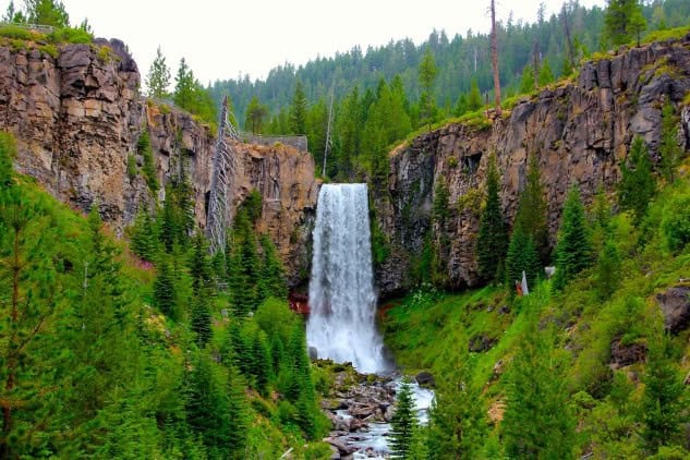
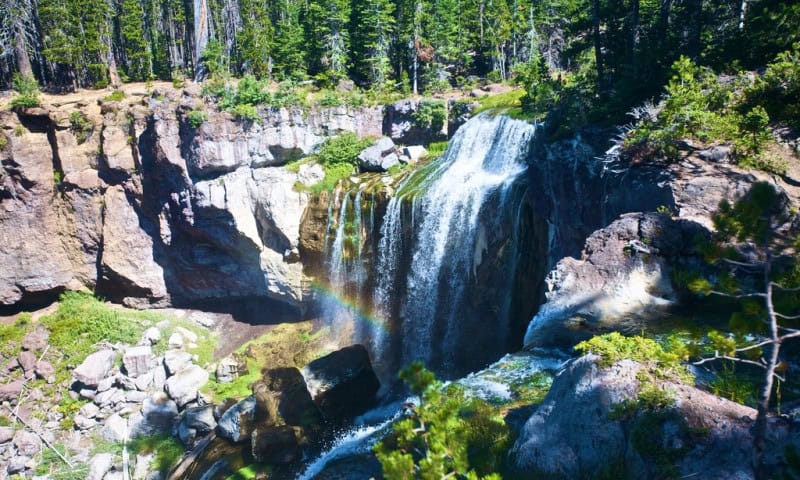
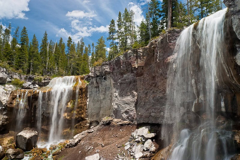
5. Paulina Waterfalls near Bend Oregon
Location & Getting There:
Within the Newberry National Volcanic Monument, about 24 miles southeast of Bend. Follow Highway 97 south to Paulina Lake Road (County Road 21) and continue to the clearly marked Paulina Falls viewpoint parking area. A Northwest Forest Pass or recreation fee is typically required.
Waterfall Details & Appearance:
Paulina Falls is a twin-cascade waterfall formed as Paulina Creek drops roughly 80 feet over a basaltic cliff. The water fans out into two channels, creating a striking split flow, especially in spring. Lava formations and tall conifers provide a unique volcanic backdrop.
Hike Details:
– Difficulty: Easy.
– Distance: 0.5 miles round trip from the upper viewpoint, with an optional trail descending to the base.
– Elevation Gain: Minimal if you stick to the overlook. Climbing back up from the falls’ base adds more challenge.
– Trail Notes: The top overlook is wheelchair-accessible with an easy path. Going down to the pool below can be steeper and more rugged.
Best Seasons & Tips:
– Late spring or early summer offers stronger flow and fewer crowds than peak summer.
– Combine the trip with a day exploring Paulina Lake, hot springs, or the Big Obsidian Flow in the same volcanic monument.
– Bring a picnic—several sites near the parking area and along the creek offer serene lunch spots.
Paulina Falls Photography Tips
- Emphasize the Twin Drops: The waterfall splits into two streams. Position your shot so both cascades are equally visible, especially from the main overlook.
- Include Volcanic Elements: Capture the distinctive basaltic rock face beneath the falls to illustrate its volcanic origins. Framing the top of the cliff can highlight layering or textures in the rock.
- Experiment with Different Exposures: A slightly faster shutter speed (around 1/125–1/200 second) might catch the waterfall’s split in sharper detail, while a longer exposure will soften it into twin silky flows.
- Seasonal Variation: In spring, you get heavier flow and fresh greens. In autumn, the changing leaves or subdued hues around the basalt can lend a different palette—adjust your white balance to enhance these seasonal colors.
Extra Tips for Waterfall Visits Around Bend
Prepare for Changing Conditions: Central Oregon weather can fluctuate greatly. Sunny mornings can turn cloudy, windy, or even snowy in late fall or early spring. Dress in layers and monitor local forecasts.
Check Road Access: Some forest roads close seasonally or become impassable during heavy snow. The Deschutes National Forest website and ranger stations can provide updates.
Leave No Trace: Dispose of waste properly, stay on official trails, and avoid stepping on fragile vegetation near stream banks. These areas are crucial habitats for local wildlife and native plants.
Mind Trail Etiquette: Many routes are multi-use. Yield to uphill hikers, and step aside for mountain bikers or horses where applicable. Keep your dog leashed when required.
Plan for Snacks & Hydration: Bring a daypack with a water bottle or hydration bladder. If you plan on picnicking by the falls, remember to carry out all trash. Some trailheads have vault toilets, but not all.
With diverse scenery—from towering basalt cliffs to dense pine forests—these waterfalls near Bend provide unique experiences for hikers, families, and outdoor enthusiasts. Whether you’re seeking an easy stroll to a scenic overlook or a longer trek into the backcountry, Central Oregon’s cascades promise memorable views and the refreshing sound of rushing water.

Content creator and writer for multiple websites including All About Glamping, Fit Living Lifestyle, and Live Dream Discover. A full-time traveler who has spoken at various travel conferences around the world.